Patterns in Street-Names: Big Houses
By Paul Tempan
A widespread pattern found in all parts of Belfast is the naming of streets after residences of merchants, politicians and nobility. For example, built for the first Marquess of Donegall c. 1807 and extended by the second Marquess, gave its name to Ormeau Road and the grounds became a public park in 1871. Ormeau is a French name meaning ‘young elm’. it first appeared in 1791 as the name of the house of Mr. Kingsmill, the agent for the Donegalls on James Williamson's map of Belfast.
Some areas have more such names than others. There is a particularly dense cluster in North Belfast in the vicinity of York Street / York Road, North Queen Street and Antrim Road. Up to the mid-19th century this was a tranquil rural area outside the city boundary, an attractive location in which to build a fine house with a view of Belfast Lough. A number of these residences were marked in open countryside north of Belfast on Taylor and Skinner’s Maps of the Roads of Ireland (1777), including Mount Collyer, Jennymount, The Grove and Parkmount. Some were sketched by Joseph Molloy in the book Belfast Scenery in Thirty Views (1832). Very few are still standing. In some cases the street-name is the only reminder that these houses existed:
Duncairn Gardens, between Antrim Road and North Queen Street – from Duncairn, the residence of Adam J. MacRory, a leading Belfast solicitor. Author Brian Keenan (b. 1950) grew up in Duncairn Gardens. He is best known for his book An Evil Cradling, an account of the four and a half years he spent as a hostage in Beirut.
Vicinage Park, off Antrim Road – from The Vicinage, the residence of Thomas McCabe, watchmaker and United Irishman. It is shown on Williamson’s map of Belfast (1791). The house became a boarding house for a seminary in 1833, and later became St. Malachy’s College.
New Lodge Road, between Antrim Road and North Queen Street – from The Lodge. On a 1791 map of Belfast, drawn by James Williamson, there are three houses close to each other in this area, each of them marked as The Lodge. The respective owners are named as Mr. G. Joy, Mr. H. Joy and Mr. Holmes.
The word ‘new’ applies to the road and not to the house name (i.e. there was no house called New Lodge). There was originally Lodge Lane, later Lodge Road, which approached the house going NW, then N from the town centre. The New Lodge Road was built later and approached the house going WNW from the docks. The upper half of this road (west of Antrim Road) is now called Cliftonville Road. Broadcaster Eamonn Holmes (b. 1959) grew up on New Lodge Road.
Spamount Street, off North Queen Street (New Lodge) – from Spamount, a house situated on the Old Carrick Road, which later became North Queen Street. The house got its name from a nearby well.
Greenmount Place, near North Queen Street (Tiger’s Bay) – from Greenmount, first recorded in 1814. In 1819 it was the residence of John Bell. Greenmount Street is an older street, now defunct, but the sign is still in place on the outside wall of the Mount Bar.
Mervue Street and Upper Mervue Street, off North Queen Street (Tiger’s Bay) – from Mervue, a house shown but unnamed on the Ordnance Survey 1st edition 6 inch map (1833). Boxer Carl Frampton (b. 1987) grew up on Upper Mervue Street.
Lilliput Street, off North Queen Street (Tiger’s Bay) – from Lilliput, built in 1760 by David Manson, a progressive educator who taught, amongst others, Mary Ann McCracken and Ellen Joy, daughter of Henry Joy. The house is shown on Williamson’s map of Belfast (1791). It was, of course, named after the fictional island country inhabited by tiny people in Gulliver’s Travels by Jonathan Swift. Manson’s school had its own magazine called The Lilliputian.
Trainfield Street, off Spamount Street (New Lodge) – from Trainfield House, built c. 1830 by mill-owner Francis Lepper. Lepper Street in the same neighbourhood takes its name from brothers Francis and Charles Lepper. Later in the 19th century Trainfield was the residence of Joseph Biggar, Nationalist politician and Member of Parliament. The house’s name alluded to its position near an army drill ground.
Fortfield Place, off Spamount Street (New Lodge) – from Fortfield, a mansion. Sir William Gillilan Johnson, Mayor of Belfast in 1849, was born at Fortfield in 1808.
Mountcollyer Avenue / Road / Street, off North Queen Street – from Mount Collyer, a house marked on Taylor and Skinner’s Maps of the Roads of Ireland (1777), just north of the town boundary. It had several notable owners/occupants, including clergyman Dr William Drummond, textile manufacturer Andrew Mulholland, and Rev Dr James Saurin, vicar of Belfast.
Rev. Dr. William Hamilton Drummond, a Presbyterian clergyman, was running a boys’ boarding school at Mount Collyer in 1806 (Benn 1880, 58). It became known as “Drummond’s Academy” (IHTA xii, 33). Dr. Drummond (1778-1865) was originally from Larne. He was minister of the second Presbyterian congregation in Rosemary Street. He also gave public lectures on scientific subjects and wrote books about the Battle of Trafalgar (1806) and the Giant’s Causeway (1807) (Hewitt 2008, 71-2). Andrew Mulholland owned Mulholland’s Mill in York Street with his brother Thomas. Andrew was elected Mayor of Belfast in 1845. A Mrs. Mulholland was recorded as a “Country Resident” dwelling at Mount Collyer in the Belfast and province of Ulster directory of 1852.
The photograph reproduced in Peggy Weir’s illustrated history North Belfast shows Mount Collyer as a large but plain two-storey house (Weir 1999, 81). The house was sometimes spelt “Mount Collier” on maps, for example on the 1st edition six-inch-to-the-mile Ordnance Survey map made in the 1830s, but the spelling with Y seems to have been favoured by the owners of the house. The origin of the house name is unclear, although Collyer (and Collier) exists as a surname.
Sir Kenneth Branagh, the actor, director, screenwriter and producer, was born in the York Street area. His family moved to a house in Mountcollyer Street shortly after his birth. Branagh is known for his film adaptations of several of Shakespeare’s plays. He has directed and acted in numerous other films, such as Peter’s Friends (with Emma Thompson, Stephen Fry, Imelda Staunton, Hugh Laurie, Rita Rudner (co-writer), Alphonsia Emmanuel and Tony Slattery). More recently, he has starred in the title role of the Swedish detective TV series Wallander (English language version).
Seaview Street / Close, off North Queen Street – probably from Sea View Cottage, first recorded in 1814. This was a different house from Sea View, situated a little further out on Shore Road, which gave its name to Crusaders F.C. football ground. In 1835 a Mr. Simms was resident at Seaview-cottage (Matier’s Belfast Directory). He was a partner in the book publishing and stationery business Simms & McIntyre operating at 20, Donegall Street.
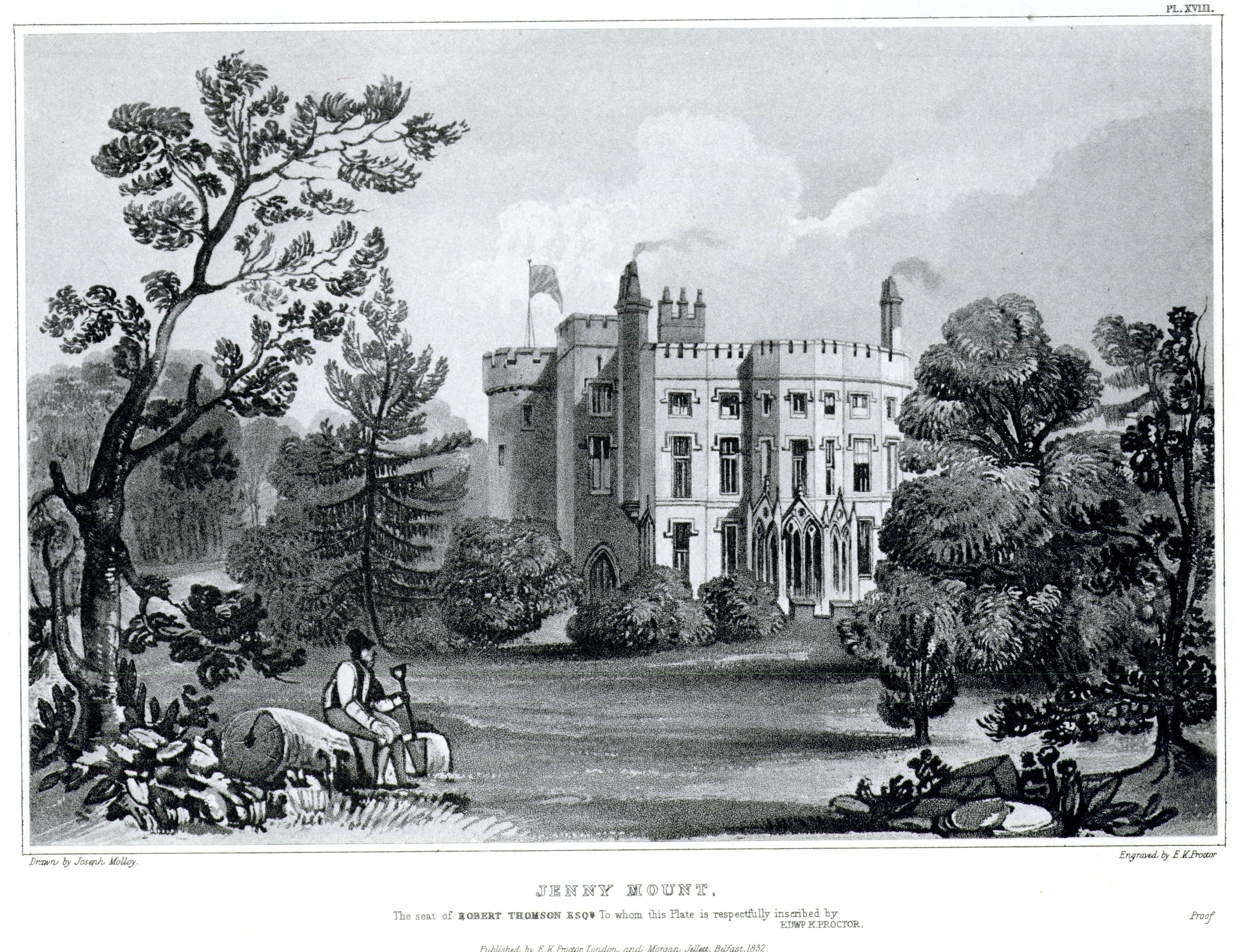
Parkmount Street / Close, off North Queen Street – probably from Parkmount, originally built for the 1st Earl of Donegall. In his article “When The Shore Road Was A Rural Retreat”, Joe Baker reports that Parkmount had a “fine timbered demesne of over 100 acres extending up to the Antrim Road… It was situated in the townland of Low-Wood, north of Skegoneill.” The house came to the Cairns family in 1796. Later it was the seat of John Mc Neile Esqr., a banker, sketched by Joseph Molloy, in Belfast Scenery (1832).
This house was located further out the Antrim Road beyond Fortwilliam, and Parkmount Road, also named from it, is in this locality. Given the distance from Parkmount Street to the former site of the house, we must also consider the possibility that the name alludes to the nearby Alexandra Park.
Jennymount Street, off York Road – could be from Jennymount, seat of Robert Thomson Esqr., but as this house was renamed Castleton in 1847 and the street was not built until 1866, it is more likely named from Jennymount Mill (built between 1856 and 1864), which in turn was named after the house. Jennymount (the house) was built by Robert Thomson c. 1775 (Benn 1880, 226) and was later the residence of John Thomson, one of the founders of the Commercial Bank, which later became the Belfast Bank (Baker 2011). The house is marked on the 1st edition six-inch-to-the-mile Ordnance Survey map made in the 1830s. On the 2nd edition map of 1846 Jennymount has been replaced by a residence called Castleton at the same site.
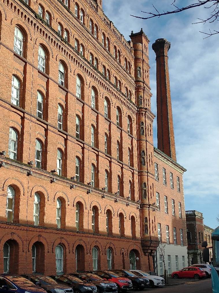
Photo: Jennymount Mill
The name Jennymount is explained as follows by George Benn in A History of the Town of Belfast, vol. ii (1880): “In another letter of the year 1782, Miss Jane Thomson writes to her cousin, the Rev. John Thomson, Presbyterian Minister of Carnmoney, announcing an event interesting to both, and dates her letter from Jennymount; doubtless this lady was the originator of the name” (Benn 1880, 226). In other words, Jenny was a pet form of Jane, referring to Jane Thomson. Nowadays we usually think of Jenny as a pet form of Jennifer, but in the 18th century it often stood for Jane.
As well as Jennymount Street, the name is also remembered in Jennymount Methodist Church, which is located very close to the site of the original house, and Jennymount Mill. The mill was designed by John Lanyon, son of Sir Charles Lanyon. There is an excellent photograph of the mill taken in 1908 and reproduced in Made In Belfast (Pollock and Parkhill 2005, 29). “Other buildings of the time such as Gallaher’s York Street Tobacco Factory have long been demolished, leaving Jennymount Mill one of the few intact industrial buildings still standing as a relic of the great age of local industry associated with textiles” (https://www.ulsterarchitecturalheritage.org.uk/case-studies/jennymount-spinning-mill/). In 2002 Jennymount Mill was re-opened as an office block and forms part of Jennymount Industrial Estate. However, it has been hard to find commercial tenants to occupy the whole building.
Sadly, Jennymount Street is now a cul-de-sac without houses or other buildings.
Castleton Avenue, off North Queen Street – from Castleton, residence of the Thompson family (formerly known as Jennymount, renamed Castleton in 1847). As Jenny Mount, seat of Robert Thomson Esqr., it was sketched by Joseph Molloy in Belfast Scenery (1832).
The house was apparently named after Jane Thomson, née Legg, who married Robert Thomson in 1761. The change of name to Castleton occurred when the house was remodelled from Georgian to Neo-Gothic style.
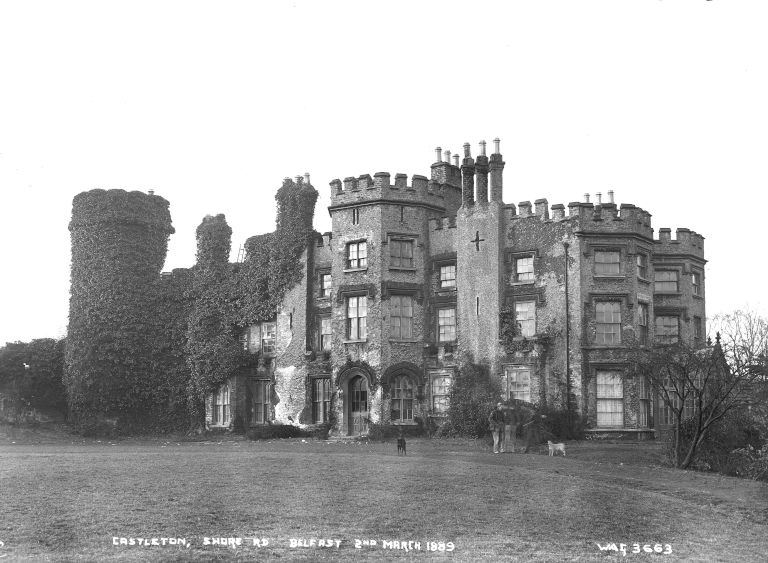
Photo: Castleton (formerly Jennymount) in 1889, courtesy of National Museums NI
Grove Court / Place, off York Road – from The Grove, a fine two-storey Georgian mansion with grounds which extended up to Antrim Road. Grove Library and Grove Wellbeing Centre now stand on this site. The house was marked on Taylor and Skinner’s Maps of the Roads of Ireland (1777), 0.75km north of the town. In 1883-4 the estate included a gate lodge, a rockery and a tank (IHTA xvii, 80). In his article “When The Shore Road Was A Rural Retreat” (https://issuu.com/glenravel/docs/1_ntbelfast/28), Joe Baker reports that the house had three different owners during its history as a private residence, namely the Simms family, then John Sinclair, then W. Barry Ritchie, the Mountpottinger felt and fertiliser manufacturer. Peggy Weir names another owner, James Carson. This was in 1807 before the time of the Simms family (Weir 1999, 79).
The Ritchie family were the last occupants of The Grove as a private residence up to 1918. It was then replaced by a spacious park and by a school (Baker 2011). The house itself was used as the District Headquarters of the Ulster Special Constabulary (B-Specials) until it was demolished in 1926 (Weir 1999, 79).
On the six-inch-to-the-mile Ordnance Survey map made 1952-67, a cycle track is shown in the Grove Playing Fields. There are also tennis courts, bowling greens and a pavilion in the park near Grove County Primary School. Baths are shown on York Road (https://www.geograph.ie/photo/2112701). These were replaced by the new pool at Grove Wellbeing Centre, which opened in 2008. The old Grove Baths were demolished in 2013. The site is now a vacant plot in the fork where North Queen Street meets York Street.
Other big houses further out in North Belfast include Dunmore, Skegoneill, Fort William, Sea View, Mount Vernon, Hopefield, Richmond and Low Wood. All of these have been demolished but also generated street-names in the vicinity. As the city expanded in the 19th century, these locations became less attractive to wealthy owners, who tended to move further out. Most were sold for the development of residential housing, but The Grove became the district headquarters of the Ulster Special Constabulary (B Specials) and then Grove Centre (library, health and leisure centre), whilst a football ground was built at Sea View.
About Paul Tempan
Paul Tempan has lived in Belfast since 2001 and has travelled Ireland as a hill-walker and as a tour guide. He undertook doctoral research on Irish place-names at Queen's University Belfast (2007-11) and worked as a research assistant, later a research fellow, at the Northern Ireland Place-Name Project (2006-13). He now works with Libraries NI and is an independent researcher.